Successful Demonstration of NGC Aerospace Crater-Based Optical Navigation in Space

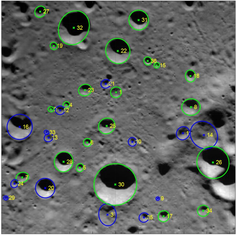
Example of detected and matched craters during descent trajectory. Matched craters shown in green.
SHERBROOKE, Quebec, Canada, [April 30th, 2025] – NGC’s crater-based optical navigation system was successfully demonstrated during Firefly Aerospace’s recent Blue Ghost lunar mission. As a payload onboard Blue Ghost Mission 1, NGC’s global lunar navigation system was tested and verified against Firefly’s primary vision navigation system after landing.
NGC’s optical navigation system uses features on the lunar surface – Moon craters – as topographical references to accurately locate vehicles around the Moon. It effectively provides a position measurement similar to what a GPS sensor does on Earth but without the infrastructure of a GPS system. Only a camera and NGC’s software are necessary.
This system, called Crater-Based Absolute Navigation (AbsNAV), is designed to autonomously determine the position of an Orbiter or a Lander in Moon geographical coordinates. This fully autonomous technique processes camera images taken from Moon orbit and during the descent, extracts craters, and matches the detected craters with a pre-stored on-board reference crater map. This reference map, containing millions of craters, is built prior to the mission based on Moon surface information and orbital imagery obtained from previous missions. The navigation system computes an estimate of the lander location with respect to the reference map. It allows estimating the lander absolute position in low lunar orbit and during the descent orbit to refine the lander position estimate and increase the accuracy at touchdown. Such technology is required to meet the challenging requirements of future Moon precision landing missions.
NGC’s system was successfully demonstrated onboard Firefly’s Blue Ghost lander using imagery acquired during descent. The analysis of the results shows that the system successfully provided position measurements with an accuracy of 100 m or better using lander imagery from altitudes ranging between 50 km and 20 km. This is achieved thanks to the detection of approximately 25 craters on average in the individual images during the descent trajectory. Overall, the observed performance was very similar to what was predicted using software simulations.
Relive Firefly’s Blue Ghost historical landing here.
Detailed analysis of the flight results continues and more detailed performance results will be shared on this website through publications to come.
NGC Aerospace would like to acknowledge the great support of Firefly Aerospace and Space-NG for supporting the integration and demonstration of the system, and the financial support of the Canadian Space Agency in the realisation of this program.